City Hall is applying the wrong planning paradigm in Norquay, DTES, Mount Pleasant, Marpole, Granview-Woodland, and West End according to the neighbours. The people are mad as hell and won’t take it anymore. Join us 24 September at the front steps of our City Hall to keep our democracy free of the wrong kind of growth. The neighbourhoods are saying they welcome investment, but will not cede their future over to large scale development. People have clearly indicated a preference for a human scale urbanism, and consultative planning processes.
Neighbours Meet
27 august 2013 Carnagie Centre. Members of the Resident’s Association of Mount Pleasant met with members of the Carnagie Community Action Project to compare notes about their involvement in the community planning process with the City. Continue reading
Shopping List for the New Neighbourhood Plan
Historic Buildings, Strathcona
Here is a primer for what to look for in the new neighbourhood plan for the Downtown Eastide the place we dubbed Vancouver’s Historic Quartiers. Continue reading
Hunger Strike for Ending Homelessnes
Noon Friday March 22nd a resident calling himself “The Artist — formerly known as Homelesss Dave” began a hunger strike for social justice and housing the homeless. The hunger strike began six days after the official start of the 40th provincial election campaign on 16 march 2013. His message on Twitter read:
“We’re not about smashing windows. We’re about smashing the old broken paradigms and building new paradigms that are more just and equal.”
Zoning Not the Right Tool
600 Block E Cordova—Signs of the Problem: Turning a back on this neighbourhood is longstanding City policy.
A new proposal in the 500-block E Cordova Street exposes the fault line in our community vision. A 2.5 FSR project will provide social housing units on the ground floor. The developer is answering local policy by providing 3 units at SRO rates of $375.
One Decision Our Way

This building was built under strata legislation. The owners hold the property in common and must deal with issues as a collective. With the new legislation, each unit will have the legal entity of a single house. Expect changes in design. No more underground parking, common roofs, and shared landscaping. Also expect changes in use. Individual units will generate more opportunities for rental housing. We see major changes to the feel and functioning of the neighbourhood as well. In these matters, small changes can usher in great qualitative differences.
Slipping below the radar, in the first week of June 2012, the Provincial Legislature passed a small amendment that made legal a form housing in this region that had been banned from the outset. As a result “the missing link” in Vancouver urbanism is now approved and ready for construction. Fee-simple (clear-title) attached housing is now legal to build in British Columbia for the fist in a long time. There really are no examples I can point to of row houses built here in the last 150 years. Row houses are there, but always missing one important feature or another. We have premised the Vancouver Historic Quariters analysis on just this reversal in policy. Read more about the implications of this change for Vancouver urbanism here.
One Decision the Other Way
Vancouver City Council approved the Mount Pleasant Community Plan on 18 November 2010 as we were completing the planning stages of this study. By March 2012, as we were finalizing this report, a Public Hearing to approve re-zoning of a 19 storey tower in the Mount Pleasant neighbourhood attracted 295 speakers. Most rose to denounce the tower as the wrong building form for their neighbourhood. On 17 April, with one abstention and one vote against, Council approved the re-zoning citing the $6.25 million cash contribution from the developer as the decisive factor. The community plan, and a two-year community outreach and consultation process, were over ruled. Read More.
The Tower on Its Side
“Tower on Its Side” (LNV 1995)
For the purposes of the SUNN: Vancouver Historic Quartiers study we have used the following density figure:
- Tower density (100 units/acre x 120 acres/quartier x 2.2 persons/unit) = 26,400 people per tower neighbourhood.
- Urban House density (75 units/acre x 120 acres/quartier x 2.2 persons/unit) = 19,800 people per walkable neighbourhood or quartier.
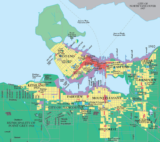
The ‘Walkable Neighbourhoods’ or Quartiers of 1910
Detail from 1910 map in: Vancouver: A Visual History (1992) by Bruce Macdonald.
The plan shows the footprint of development in the City of Vancouver 25 years after the railway arrived, and just four years before the opening of the Panama Canal. The latter triggered a building boom in Vancouver in 1908 the full extent of which is represented here. The 1910 Macdonald map presents an enigmatic portrait of a city about to escape the orbit or limits placed by total reliance on walking and horses, and already embracing the possibilities for extension presented by electrified rail transportation. The values of the walkable urbanism are fully on view. Yet, as we compare this map to the growth of streetcar tracks below, it becomes clear that a new set of values is already expressed in the map. Bruce Macdonald comments via e-mail how the walkability of Vancouver’s named urban villages show a keen resemblance to the quartiers. Continue reading
A Community Forum: The Density Fallacy
Can we build high density neighbourhoods without building towers? A Community Forum will be held in Mount Pleasant where the Rezoning Hearings for the 19-storey RIZE Development at Main and Broadway are showing overwhelming neighbourhood opposition for tower forms outside the downtown. Come and join the discussion with a panel of experts. Continue reading
Towering drawbacks
Richards & Davie, Vancouver
Prof. Patrick Condon, senior researcher with the Design Centre for Sustainability at UBC, reports back on the tower and podium form’s suitability for Vancouver neighbourhoods and quartiers (full article here):
First, if you follow [towers & suburban sprawl] approach you end up with two cities. A city of gleaming glass towers spread like beads on the string of the Skytrain line, disconnected with the surrounding areas they overshadow. Continue reading
Mount Pleasant Community Plan hits the 19-storey Wall
Presentation to the Rise Tower, Mount Pleasant Public Hearing:
I have been a property owner in Mount Pleasant since 1988. I attended the open house at the community centre last year, had an extensive discussion with the lead planner, and came away perfectly impressed with the fact that it would be… business as usual.
Mr. Mayor, there is a cancer spreading over our city.
Unless it is stopped, CD1 zoning will ravage our neighborhoods. Not just Mount Pleasant, but all our neighbourhoods. Continue reading


