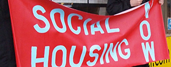
Hunger Strike for Ending Homelessnes

Social_Housing_Now

Noon Friday March 22nd a resident calling himself “The Artist — formerly known as Homelesss Dave” began a hunger strike for social justice and housing the homeless. The hunger strike began six days after the official start of the 40th provincial election campaign on 16 march 2013. His message on Twitter read:

 “We’re not about smashing windows. We’re about smashing the old broken paradigms and building new paradigms that are more just and equal.”

Continue reading

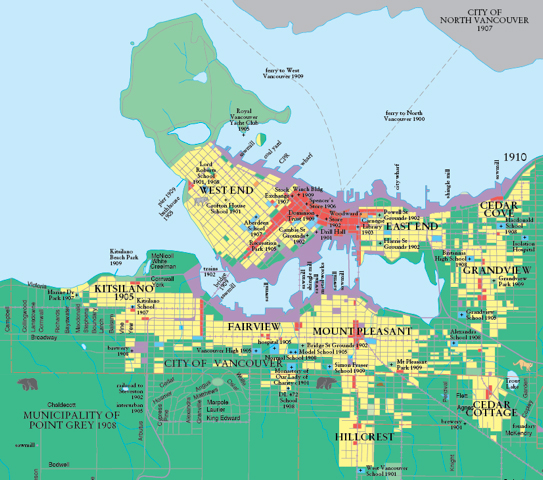
The ‘Walkable Neighbourhoods’ or Quartiers of 1910

Detail from 1910 map in: Vancouver: A Visual History (1992) by Bruce Macdonald.

The plan shows the footprint of development in the City of Vancouver 25 years after the railway arrived, and just four years before the opening of the Panama Canal. The latter triggered a building boom in Vancouver in 1908 the full extent of which is represented here. The 1910 Macdonald map presents an enigmatic portrait of a city about to escape the orbit or limits placed by total reliance on walking and horses, and already embracing the possibilities for extension presented by electrified rail transportation. The values of the walkable urbanism are fully on view. Yet, as we compare this map to the growth of streetcar tracks below, it becomes clear that a new set of values is already expressed in the map. Bruce Macdonald comments via e-mail how the walkability of Vancouver’s named urban villages show a keen resemblance to the quartiers. Continue reading

Livable streets, walkable neighbourhoods, affordable regions

Princess Street, Strathcona

If we are to draw a single conclusion from our the Vancouver Historic Quartiers working process, it would be that urbanism is a phenomenon of our own creation built across several scales of place and spanning centuries of time. Our findings are consistent with the work of others. The quality of the street environment—its “livability”—became our litmus test for measuring urban functioning at the local or district scale; we used the level of “walkability and social mixing” as the measure of urban functioning at the scale of the neighbourhood or quartier; and we used the “affordability of housing” as the measure for urban functioning at the scale of the region as a whole. By establishing different measures for urban functioning at different scales we were finally able to make sense of the urban whole. In the Vancouver’s Historic Quartiers we discovered the finest single piece of urbanism in our region. Continue reading

Urban Re-use and Incremental Redevelopment

The plan above shows the full extent of industrial build out in the Historic Quartiers fueled by the 1920’s vision of sea ports, new railways (CPR 1886; CN 1915), and the opening of the Panama Canal (1914):

[F]irst and foremost Vancouver is a great seaport and… practically the sole ocean port of half a continent, inhabited by a progressive and increasing population, has on its outskirts a river valley with great agricultural possibilities, with a hinterland rich in minerals, lumber and raw materials for manufacture, and adjoining at the moderate distance of five hundred miles the greatest granary of the world. (Bartholomew 1929 : p. 29) Continue reading

Simply the Best

We have lost sight of the social, economic, and environmental values embodied by the tradition engendered in the urbanism of the Vancouver Historic Quartiers. If we have forgotten how to look at the city, perhaps it is because we are driving by too fast, or because we are labouring under the false nihilism of the ‘Degree Zero’ doctrines of Modern urbanism. Everywhere we turn in the Historic Quartiers we discover another place, another space, another set of architectural elements honed to embody the values of community, and the values of place. Thickly encrusted by layers of benign neglect, here in our oldest and most venerable places, we can recover the longest, continuous tradition in urbanism, and secure a sustainable future.

Continue reading

Gassy’s Town

Prior to the arrival of railway, Gastown was as a one-street commercial district serving the Hastings Mill population, and all who arrived over the False Creek bridge from New Westminster, or by boat to any of its rickety floats. With the first railway station located immediately to the west, and the surrounding land a timbered wilderness, Gastown was the first beneficiary of the forces unleashed by the transcontinental.
Continue reading

The Figuration of Place & the Urban Room

Maple Tree Square

The Figuration of Place & the Urban Room

Inside the urban room we stand in a space in the city where we can see the buildings all around. It is a place where the linear tyranny of the street is finally broken, and where the distance separating the buildings can be set to resonate with the mechanisms of human sense perception. When the ratio of the building height, to the distance between the buildings can be described by small, whole-numbers, then a powerful and lasting impression is created in our memory that we term the urban room.

In the long streets of cities platted with regular orthogonal grids one place can look very much like another. In sharp contradistinction, the experience of the urban room is something altogether different.

Continue reading

Modernity and Modern Urbanism

“The construction of the Distributor Street and the absence of skyscrapers will spread business evenly over the area and prevent undue traffic congestion.”

Harland Bartholomew. A Plan for the City of Vancouver, British Columbia. 1929.

In 1929 the Bartholomew Plan sounded a warning about skyscrapers that has gone generally unheeded in the modern world. While on the one hand, a general consensus was established after 1960 that tower districts would make up the business district of most cities; on the other, towers as the default option for neighbourhood intensification typically face strong opposition. More puzzling still is the view that towers, or skyscrapers, are the proper expression for sustainable urbanism. A position that carefully avoids answering certain irrefutable facts. Continue reading

The Hastings Mill Townsite

CPR Survey of Hastings Mill Site in 1886

Maj. J.S. Matthews, Early Vancouver Vol. 3 (Vancouver, City of Vancouver, 2011) p. 78.

The 1884 map of the Hastings Mill townsite, annotated in the 1930’s by Maj. Matthews, shows the buildings that housed and serviced the resident work force, and the curving Railway Avenue platted by the CPR mirroring the bend in the railway’s main trunk. The bend follows the contours of the land, tacking to the sea to stay on level ground. The north side of Railway Avenue replaced cottages and structures numbered 1-13 and 66-68. The railway tracks demolished most of the rest. The mill remained in operation into the late 1920’s..

The significance of the Hastings Mill Townsite is that it provided the focus for the new settlements forming around it. Continue reading

The Smoking Gun

1929 Proposed Re-Zoning, The Old East End

In 1929, as the City prepared to amalgamate with the municipalities of Point Grey and South Vancouver, the St. Louis Planning Firm of Harland Bartholomew was hired to draw an urban design plan for the city after expansion.  Titled A Plan for the City of  Vancouver, British Columbia, the Bartholomew plan spells out the strategy to eradicate the old East End. Zoning the entire area as either industrial or commercial, the Bartholomew plan envisions wiping out 65 years of continuous settlement in the old East End—longer if we consider aboriginal sites. Compared to the John Aitken plan of the same area in 1890, the place is barely recognizable. Continue reading

Historic Districts and Quartiers

2011 Vancouver’s Historic Districts

Using historical analysis we have identified five key settlement areas in the era immediately following the arrival of the Canadian Pacific Railway—the corporation that picked the name “Vancouver” for its pacific terminus:

  1. The Hastings Mill Townsite and Japantown (the townsite was re-platted as Railway Avenue by the CPR).
  2. Gastown (The Granville Townsite).
  3. Chinatown.
  4. The cottage lots, including those dubbed “Strathcona” in the 1950’s.
  5. The Industrial quartier. 

Aboriginal people were among the groups denied land ownership rights. Although their presence preceded European and Asian settlement by millennia, because they did not own land, today  no district, quartier or neighborhood carries their name.

Continue reading

The Charrette Plan

The Charrette Intensification Plan

The final results of the charrette show the potential intensification for the area as:

The final Charrette plan shows incremental intensification in the Historic Quartiers with 15,500 units, housing 35,000 new residents, for a total area population of 55,000.


Continue reading